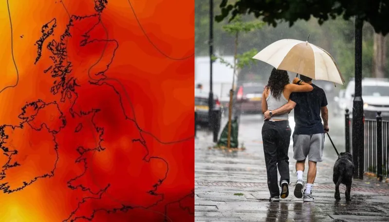
Brits are being warned not to let this week's heavy rain fool them, as forecasters say a fresh heatwave could soon send temperatures soaring to 32C across parts of the United Kingdom.
While much of the country is set to endure wet and unsettled conditions over the coming days, meteorologists believe the cooler spell may only be temporary before summer heat returns later this month.
The UK Met Office has warned that thunderstorms, hail and heavy downpours could affect several regions this week as a band of rain moves across the country. Forecasters said Tuesday is expected to be particularly unsettled, with the risk of lightning and locally intense showers. Rain is then forecast to become more widespread from Thursday onward.
However, weather models suggest the current cool spell could give way to much warmer conditions, with temperatures potentially climbing as high as 32C in the weeks ahead. The forecast follows an extraordinary start to summer that has already produced one of the UK's earliest and most significant heatwaves on record.
A Met Office spokesperson said: "A band of rain, heavy at times, will gradually move south-eastwards across the UK."
For now, temperatures are expected to remain relatively modest, generally ranging between 15C and 18C across many areas. By the weekend, however, conditions are forecast to improve, with highs of 24C to 25C expected in several regions before hotter weather potentially develops later in June.
The prospect of another heatwave comes after the UK experienced record-breaking warmth in May. Temperatures exceeded 32C in parts of England, while some areas officially entered heatwave territory after recording three consecutive days above regional thresholds. In some locations, temperatures even approached 35C, making it one of the hottest May periods ever recorded in Britain.
Forecasters have also indicated that the likelihood of heatwave conditions during summer 2026 is higher than normal. According to the Met Office's long-range outlook, hotter-than-average conditions are more likely this summer compared with historical averages, raising the possibility of multiple heatwaves between June and August.
The return of prolonged hot weather could create challenges beyond discomfort. Water companies and government officials are already monitoring supplies after more than a billion litres of additional water were reportedly consumed during last month's hot spell. Authorities are also watching for increased wildfire risks and pressure on health services if temperatures surge again.
The latest forecasts highlight the UK's increasingly volatile weather pattern, with heavy rain, thunderstorms and heatwaves occurring within days of each other. Weather experts say such rapid swings between cool, wet conditions and extreme heat are becoming more common as average temperatures continue to rise.
For millions of Britons, this week's rain may provide temporary relief, but forecasters warn that summer's biggest heat could still be just around the corner.